Maps
A map is a drawing or picture that is used to show where places are. Maps have some basic parts that make it easier to use them. These parts are title, compass, key, scale, and symbols.
Here is a map of the United States:

And here is a map of the world:

And here is a series of videos about maps:
Parts of a Map
Title - The title of a map tells you what the map is showing. Here's an example of a map title:

The title of this map tells you that the map shows the city of London in Queen Elizabeth's Time.
Compass - The compass of a map shows you the directions on the map. There are four cardinal directions: North, South, East, and West. Here's an example of a map compass:

Key - The key of a map shows the map's symbols and tells you what they stand for. Here is an example of a map key:

This map key shows the symbols for a park, gas station, railroad, road, and campground. Now that you know what the symbols stand for, you will know what you are looking at when you look at the map.
Symbols - Symbols are pictures that stand for something else. They are found on the map and in the map key. In the map key above, you see symbols. The red circle with a "G" inside of it is the symbol for a gas station. The blue line is the symbol for a road.
Scale - A scale is like a ruler. It shows the distances on a map. The distance on a map is much smaller than the distance in real life. So, the scale shows you how to measure the distance on the map and change it to the distance in real life. Here's an example of a map scale:

7 Continents - There are seven continents found on Earth. They are: North America, South America, Europe, Asia, Africa, Australia, Antarctica.
Here is a map of the 7 continents:

5 Oceans - There are 5 oceans found on Earth. They are: Atlantic Ocean, Pacific Ocean, Indian Ocean, Arctic Ocean, and Southern Ocean.
Here is a map that shows the 5 oceans:

Prime Meridian/Equator - The Prime Meridian and the Equator are imaginary lines that help us find places on Earth. The Prime Meridian is an imaginary line that goes vertically (up and down) through the middle of the Earth. The Equator is an imaginary line that goes horizontally (across) through the middle of the Earth.
Here is a picture that shows the Prime Meridian and the Equator:

Poles - There are two poles, one at the top of the Earth (North Pole) and one at the bottom of the Earth (South Pole).
Countries (Canada/Mexico/United States) - These are the three countries that we will be focused on in third grade. Canada is the country to the north of the United States and Mexico is the country to the south of the United States.
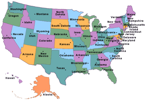
States - A state is a smaller part of a country. The United States has 50 states.
Here is a map that shows the 50 states of the United States:
thats nice
ReplyDelete